-

Municipal Dreams wrote a new post on the site reviewer4you.com 1 month, 1 week ago
Chemin-Vert, Reims: a French ‘Garden City’
 The ‘Garden City’ of Chemin-Vert was an unanticipated pleasure on a […]
 -
Municipal Dreams wrote a new post on the site reviewer4you.com 1 month, 1 week ago
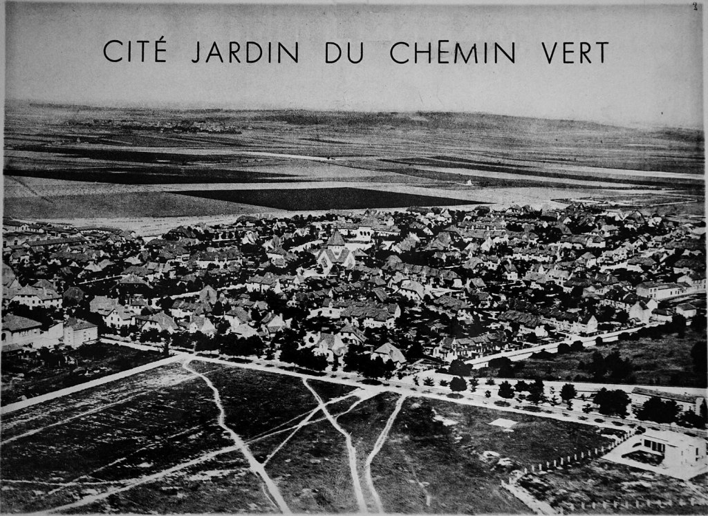
Chemin-Vert, Reims: Photo Supplement
 These photographs are a supplement to my main post providing a full history and description of the Chemin-Vert ‘Garden City’. Housing The Église Saint-Nicaise
 -
Municipal Dreams wrote a new post on the site reviewer4you.com 1 month, 1 week ago
Municipal Housing in Zurich | Municipal Dreams
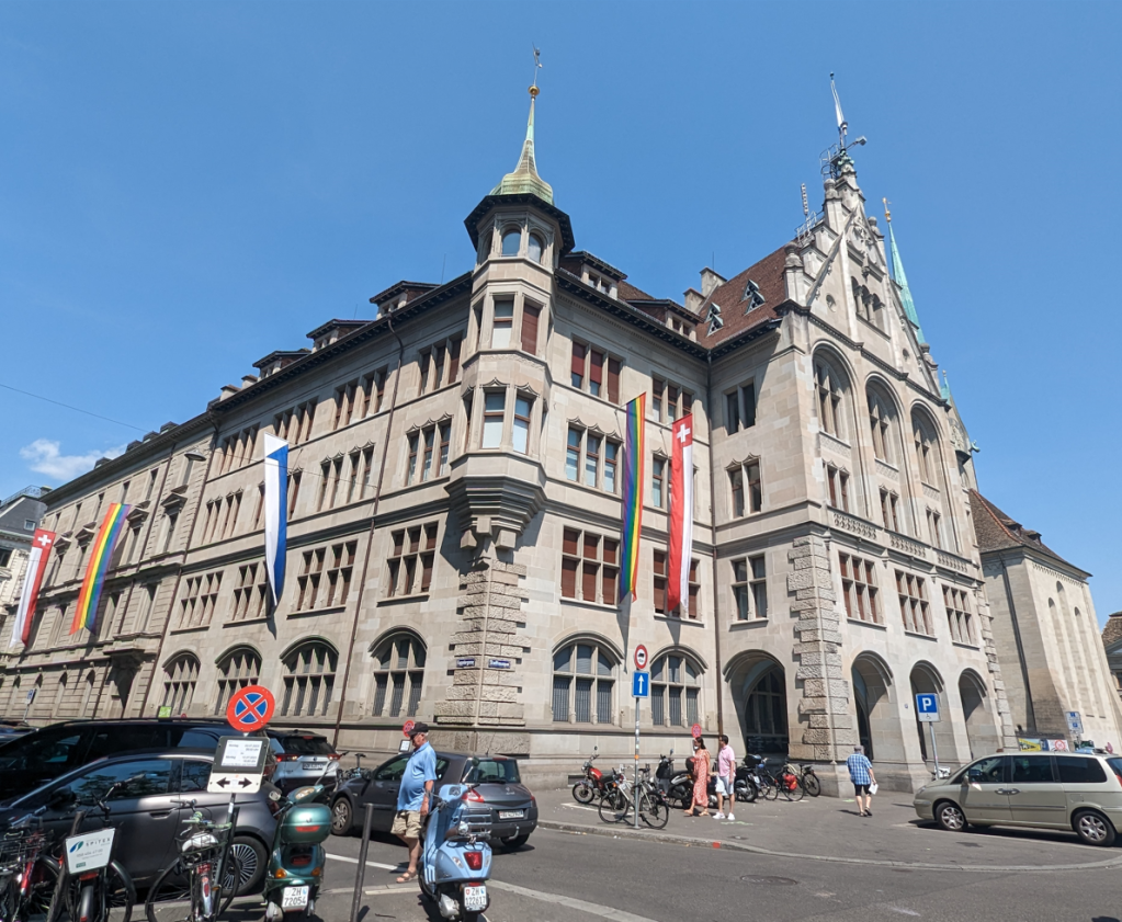 If you think of Switzerland (beyond cowbells and cuckoo […]
 -
Municipal Dreams wrote a new post on the site reviewer4you.com 1 month, 1 week ago
A Joyful Family Home? | Municipal Dreams
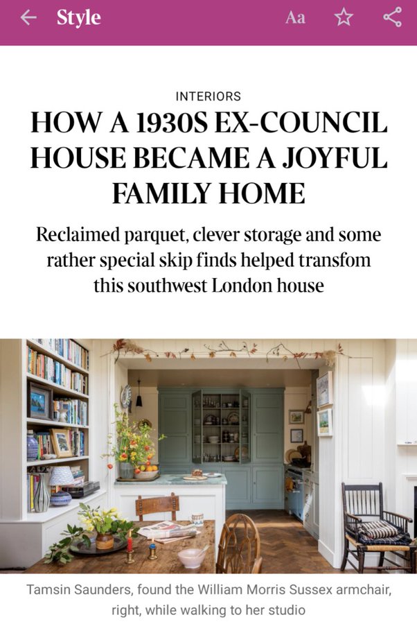 On the 9th July, the Sunday Times posted an article in their Style […]
 -
Municipal Dreams wrote a new post on the site reviewer4you.com 1 month, 1 week ago
-
Municipal Dreams wrote a new post on the site reviewer4you.com 1 month, 1 week ago
Stonebridge Park, Brent: a Century of Change. Part II: ‘Stonebridge will be ideal to live in’ – a New Utopia and the Lived Realities
 I’m very pleased to feature a new post from Jill Stewart, the second of a three-part series. Jill is Associate Professor in Public Health at the University of Greenwich and has worked in housing for over 30 years. She has written previously for Municipal Dreams about the earliest environmental health practitioners before 1914 and after the First World War and on the South Oxhey Estate. This is my review of one of Jill’s books, Environmental Health and Housing: Issues for Public Health. You can follow Jill on social media @Jill_L_Stewart and @housing-jill.bsky.social and see more of her work on her personal website, Housing, Health, Creativity. In last week’s post, we left Stonebridge Park in the early 1950s. By the end of the decade plans were afoot for addressing poor housing in the Stonebridge area once and for all. By 1959, the Medical Officer of Health (MoH) reported that ‘in spite of the shortage of Public Health Inspectors … more inspections were carried out … Inspectors were engaged on special surveys – two on the proposed redevelopment area, one on the proposed improvement area, and two on the smoke control areas’. (1) By 1961, the MoH (2) reported that: The improvement of housing conditions still remains a very important function of the health department … The Minister of Housing and Local Government has confirmed, with modifications, the Middlesex County Council scheme for the Stonebridge Proposed Redevelopment Area. Two owners were prosecuted for allowing occupation in basements where closing orders had been made, and one owner was prosecuted twice for contravening the overcrowding provisions of the Housing Act. Much work has been done informally to reduce overcrowding in houses, particularly for those let in multiple occupation. It is not clear where in Willesden these latter cases are, but it adds to the picture of the housing challenges faced. Fig 1: MoH report 1964 based on 1961 census: Source Wellcome Library, London’s Pulse: Medical Officer of Health reports 1848-1972 and reproduced under a Creative Commons Attribution 4.0 International licence. The 1961 census cited in the MoH reports for 1963 and 1964 (3, 4) recorded the ongoing housing conditions in the general Willesden area demonstrating more persons per acre than other districts in Middlesex (except Tottenham) and the percentage of households at more than 1 ½ per room at the highest in the county and higher than the averages for London, with low levels of public space and many with no garden. The percentages of households either sharing or without a cold tap, hot tap or fixed bath was more than double the county average and above that of London (MoH, 1963:8) (3); see Figure 1 below for MoH 1964 (4) report. Change Again? Into the 1950s and 60s society was changing more widely; there was an optimism in the air. At the Ace Café (Figure 2), bikers were racing along the North Circular to the iron bridge and back to the length of a 45 RPM record, achieving cult status amongst young bikers and adding another dimension and layer to the history of Stonebridge Park. The 1963 film The Leather Boys (5) captures some of this time. The ReelStreets website includes stills of the Ace Café and general Stonebridge area that readers may recognise (with more recent photographs alongside). (6) Fig 2: The Ace Café, Stonebridge. Photograph ©Jill Stewart 2023 Despite a wider 1960s optimism, local housing stock was in decline both in conditions and overcrowding. As the old boroughs of Willesden (Labour) and Wembley (Conservative) combined to form the London Borough of Brent, in 1964 the MoH (4) reflected on the uncomfortable process this merger had been and said: (4) Wembley is fortunate to be relatively free (from) the legacy of bad housing, which continues to be a source of considerable anxiety in Willesden. Resources and staff are unfortunately insufficient to alleviate it fully, and rehousing perforce is a long-term remedy. Much has been done to cope with the worst aspects, so that living conditions are at least tolerable for many; but it is to be regretted that the Housing Act, 1961, with its measures against multi-occupation, has not overcome the wiles of the worst type of landlord. Further legislation is essential to control this exploitation of tenants. An aerial photograph of Stonebridge was taken around this time – see Figure 3. Fig 3: Aerial view of Stonebridge 1965. Reproduced by kind permission of Brent Museum and Archives The Milner Holland Report of 1965 on Housing in Greater London (7) (including the Middlesex area) demonstrated the extent of poor housing. In response to this Report, Lord Silkin said: (8) From the point of view of human happiness and dignity, I believe that this is the greatest task which this Government, or any future Government, will have to face. I think that we shall be judged by the contribution we make towards a solution of this terrible problem. Until every family in the country has a decent home, this task must not be abandoned or relaxed. I wish the Government every success, and in undertaking this task they have all my blessings. Legislation provided for targeted interventions. The Housing Act 1964 introduced General Improvement Areas, to invest in private sector housing stock and complement clearance and redevelopment programmes. The Housing Act 1974 introduced Housing Action Areas to focus on areas of housing stress and help prevent the need for clearance. The scene was thus set for area-based grants to invest in and maintain private sector housing stock, and these continued in various forms for many years. Despite this, some areas like Stonebridge Park were being prepared instead for large-scale clearance and redevelopment. ‘Stonebridge will be ideal to live in‘ By February 1960, the Willesden Civic Review (9) promised a brave new world: ‘Stonebridge will be ideal to live in’ (see Figure 4) if the fifteen year redevelopment plan combining flats, maisonettes, houses in green spaces, parks and other open space, received Ministry approval. Fig 4: Willesden Civic Review, February 1960. Reproduced by kind permission of Brent Museum and Archives The Changing Face of Stonebridge booklet proudly proclaimed: (10) The proposal is to construct a series of multi-storey blocks of flats, of varying heights, and low-rise housing totalling three to four hundred units. The ‘deck’ principle, as proposed for the Chalkhill [Wembley, now demolished] scheme, will permit pedestrians to travel, mostly under cover, from any one part of the housing area to another by a nine foot wide “artery” running the full extent of the blocks. These ‘decks’ will be reached by passenger lifts and tradesmen will find ease in delivering their products by freight lifts which will accommodate vehicles such as milk floats; they can then travel throughout the whole area. It added: ‘The area will provide new housing of the most modern design and construction. A total of 2169 dwellings for over 6500 persons covering a total area, including well planned open space, of 100 acres. The approximate estimated cost of the entire scheme is in the region of ten million pounds.’ See Figures 5 and 6 from the same booklet. Fig 5: Illustrations from The Changing Face of Stonebridge booklet. Reproduced by kind permission of Brent Museum and Archives Fig 6: Illustrations from The Changing Face of Stonebridge booklet. Reproduced by kind permission of Brent Museum and Archives The – by then – London Borough of Brent issued its programme for the opening of Phases 1 and 2 of the Stonebridge Redevelopment Scheme on Saturday 8th April 1967, with guests invited to assemble at the Services Rendered Club on Hillside, NW10 at 10.30am. The Chairman of the Housing Committee, Mayor and Leaders were there, plus the contractors George Wimpey Ltd, with viewing of specimen flats, light refreshments and cocktails. (10) View of Amundsen House with Shackleton House in foreground, 1988. These were the first completed blocks of the estate, approved by Willesden Municipal Borough Council in 1965. © Prof. Miles Glendinning, Tower Block, University of Edinburgh, and reproduced under a Creative Commons licence. The Mayor of Brent, Alderman George Marshall, opened five new blocks of flats in Stonebridge Park in April 1967, built by Wimpey, proud of their ‘record as a foremost, progressive housing authority’ using the ‘latest industrialised building techniques … [as part of] …the massive new seven-year redevelopment programme for Stonebridge [at a] cost nearly £1 million’. (11) The alderman supposed that: Ultimately a great number of people possibly for the first time in their lives will be provided with good modern accommodation, improved amenities and a better environment in which to live … We are giving them the opportunity to lead a fuller and more adequate life. The Housing Committee chair, Alderman Philip Hartley, added: ‘We must remember that here we are dealing with the lives, the hopes and the future of people’. The council leader George Swanell said: ‘I hope it will not now be very long before the whole of Stonebridge is pulled down and redeveloped’. And the Conservative councillor, Denis Jackson, indicated that the ‘modern standards compared favourably with anything built by private developers’. (11) Looking ahead to 1972 and the completion of a ‘space age project for 2000 homes’, the Wembley Mercury in 1968 reported that the estate was now well underway at a cost of £8 million to provide: (12) Tall, slim towers of gleaming flats, some as high as 21 storeys, and joined together by ‘streets in the sky,’ will house tenants who once lived in slums or near-slum two storey ‘homes’. The Borough Architect was Mr Adrian Beckett, and plans and models were displayed locally. Recalling this, one resident told me that at the time there was great excitement and optimism about the redevelopment. Wholescale redevelopment and community: lives captured in photography and film Of course, such fundamental plans have a human and more unpredictable side over time than any planned utopia. The lengthy process of top-down compulsory purchase, rehousing, area clearance and wholescale redevelopment, displaced families and communities in an unfamiliar new living environment can set in place a whole set of unintended consequences, both during the process and in the longer term. Considering the extent of clearance and redevelopment in the 1960s and 70s, there is relatively little documented about the effects and lived experience of communities during this process. If largely absence from literature, documentary photographers help us to understand the more subjective side of area (slum) clearance and redevelopment. Nick Hedges shows us through his exemplary documentary photography how it felt, day to day, to live in poor housing awaiting demolition. Many will be familiar with his photographs for the housing campaign group Shelter in the later 1960s but, perhaps less well known, he also took photographs in a Harlesden hostel. Whilst in the area he captured the shots below. It is not certain whether these are Harlesden or Stonebridge Park – perhaps a reader may know, or even recognise the people in the pictures? Nick Hedges shows us what poor housing conditions did to people, their health and morale. In his website he tells us that: (13) The families depicted were caught in a never ending cycle of power, insecurity, and frequently ill health. Their evidence despair reflects the complete loss of hope in there ever being any positive resolution to their deprivation. He adds that ‘slum clearance, which had become very necessary, was frequently a long winded process, in which residents were left side by side with half demolished properties and litter strewn wastelands’. (14) Fig 7: Housing in the locality. Reproduced by kind permission of Nick Hedges © http://www.nickhedgesphotography.co.uk Fig 8: Housing in the locality. Reproduced by kind permission of Nick Hedges © http://www.nickhedgesphotography.co.uk There is a very unexpected source of film capturing the last of some of Stonebridge Park’s Victorian terraces as they were literally awaiting demolition in 1973. The 14 (15) – starring Jack Wild and June Brown – was filmed there just prior to the bulldozers moving in, creating the backdrop and based on a true story. The family’s home is then boarded awaiting demolition, with some of the then new flats visible. There are multiple screen captures from The 14 in ReelStreets (16) of the then terraces awaiting demolition and the now demolished housing at Stonebridge Park. Stills number 10-12 show Victorian terraces in Shelly Road, Milton Avenue, Mordaunt Road and the new flats in Shrewsbury Crescent and Wilmers Court, 16, 20-21 Shelley Road and Milton Avenue. 24-27 show Mordaunt Road and Shelly Road and the then ‘new’ flats: Mordaunt House and in Shrewsbury Crescent and Wilmers Court, and 46-47 again Mordaunt Road and Shelley Road. The creator has added a link to show how these areas later looking in April 2017. The photographs below taken in the 1970s show Mrs Delaney of Carlyle Avenue, referred to as her ‘slum’. (Remember that this street was identified in the MoH 1933 report, see last week’s post, Figure 10 listing many of these streets). Fig 9: Mrs Delaney outside her ‘slum’, 33 Carlyle Avenue, Stonebridge, 1970s. Reproduced by kind permission of Brent Museum and Archives Fig 10: Mrs Delaney inside her ‘slum’, 33 Carlyle Avenue, Stonebridge, 1970s. Reproduced by kind permission of Brent Museum and Archives There has of course been much criticism of many area redevelopment schemes that paid little regard to the fabric of existing communities, despite some of the major advantages that came from new housing design built to generous Parker Morris Standards). For example, I was told: ‘We didn’t have any choice’ by one resident when I asked about this many years later. Many long term residents had their homes, whether as owner occupiers or tenants, compulsorily purchased and they were moved to new and separate locations both within Stonebridge Park, but also other places in Willesden area, such as the new Church End estate. Families and neighbours who had lived in streets together for years were split. Some communities never recovered from this process of ‘slum clearance’ and kinship ties which hold immense importance in health and wellbeing and are hard – if not impossible – to replace or replicate. Municipal dreams turned sour? It feels uncomfortable to write in a post celebrating council housing to also talk about what did not go so well. Although the roots of tower block estates like Stonebridge Park may have been in modernism and with optimistic intentions, many were never truly modernist in their interpretation and design. The tower blocks at Stonebridge Park for example bore little relation to surrounding architecture and had an inhuman, forbidding appearance, in settings that were sometimes unusable. It is not clear at Stonebridge Park if corners were cut but the original design was planned to the meet the railway and it did not reach there as the artwork suggests in Figure 6 (This was not what actually happened in the end. It is not clear why, since the streets backing onto the railway, including Albert Terrance (Fig 11) are still there to this day. Fig 11: Albert Terrace, backing onto the railway, that escaped the original demolition in the 1960s (see also overall plan Fig 6 above). Photograph ©Jill Stewart, 2023 Estates like Stonebridge took a top-down approach and were not tried and tested. There had been little forethought as to how such estates would – or even could – be maintained and repaired, as well as managed with the new challenges presented. There were also issues around housing maintenance and repair, management, accountability and housing allocation. The environment became poorer and disadvantage set in. It would be easy here to present an overly simplistic overview to what is in fact a highly complex set of circumstances, but in essence for many Stonebridge became less desirable to live in and its homes harder to let. It felt like a downward spiral, with little sign of hope that things would change. As early as 1973, the Wembley and Kingsbury News (17) reported an ‘barrage of angry protest’ from more than 100 residents of the new Stonebridge Housing Estate. There were allegations of design faults, lift breakdowns, vandalism, dampness inside the flats and flooding of landings and walkways and improper use of play areas. It was also reported that there was ‘rowdyism and gang warfare on the estate, making life intolerable for many tenants’. The Council put forward several solutions including policing, security and possible eviction and added that once the estate was completed there would be more available space, a community centre and a designated welfare officer. This photograph of the Stonebridge estate map taken in 1988 perhaps captures something of the area’s decline. © Prof. Miles Glendinning, Tower Block, University of Edinburgh, and reproduced under a Creative Commons licence. By 1978, the London Borough of Brent established pilot projects at Chalkhill, South Kilburn and Stonebridge Estates (18) due to concerns about difficulties tenants experienced in living in high rise, high density estates. It was found that homeless families were allocated in higher numbers to these estates than the rest of the borough and in Stonebridge a system was introduced to reduce allocations to one-parent families. As a result of the study, Stonebridge was designated a priority for a five-year plan, including the Bus Garage project. The survey overall proposed more working with local community groups. The Struggle for Stonebridge documentary was broadcast in 1987 and focused on the Harlesden People’s Community Council (HPCC) formed in 1980 by young black Stonebridge residents and documenting their efforts to redevelop the bus depot to help prevent race uprisings as in Toxteth and Brixton. It attracted much attention and showcased some of the tensions in the area between the council and the community, alongside conflicting ideologies (19, 20). Fig 12: Harlesden Peoples Community Council, From the Stonebridge Bus Garage … to the Stonebridge Community Complex, 1984. Reproduced by kind permission of Brent Museum and Archives So, by the late 1980s, there were multiple complex and interrelated factors that needed to be addressed. In next week’s post we take a look at how Stonebridge looked then, how things were starting to change and what happened next. References (1) MoH for Willesden Report 1959 (2) MoH for Willesden Report 1961 (3) MoH for Willesden Report 1963 (4) MoH for Willesden Report 1964 (5) The trailer to the film can be viewed on YouTube (6) Reelstreets, The Leather Boys (7) Milner Holland Report on London Housing (HL Deb 29 March 1965 vol 264 cc836-94836). The report can be viewed online here. (8) Lord Silkin speaking on the Milner Holland Report, Hansard, 22 March 1965. (9) ‘Stonebridge will be ideal to live in’, Willesden Civic Review, February 1960 (10) The Changing Face of Stonebridge booklet, London Borough of Brent, 8 April 1967; programme for opening ceremony (11) ‘New flats in Stonebridge are opened’, Willesden and Brent Chronicle, 14 April 1967 (12) ‘72 – an £8m space-age project for 2000 New Homes (in Stonebridge)’, Wembley Mercury, 13 January 1967 (13) Nick Hedges, Families and the Interiors of Slum Housing (14) Nick Hedges, The Environment of Slum Housing (15) The trailer for this film can be viewed on YouTube. (16) Reel Streets, The 14 (17) ‘Tenants slam Brent over new estate’, Wembley and Kingsbury News 1 July 1973 (18) ‘London Borough of Brent. Who Lives Where? A Survey of Tenancies on Chalkhill, South Kilburn and Stonebridge Estates’, London Borough of Brent, 1982 (unpublished) (19) ‘Harlesden Peoples Community Council, From the Stonebridge Bus Garage … to the Stonebridge Community Complex’, 1984 (unpublished) (20) In-person film screening: The Struggle for Stonebridge. Referred to as ‘a ‘The Struggle for Stonebridge: Race, Architecture and the Harlesden People’s Community Council’ Acknowledgements With thanks to the Brent Archives, Nick Hedges and the Wellcome Library for its online collection of Medical Officer of Health reports. […]
 -
Municipal Dreams wrote a new post on the site reviewer4you.com 1 month, 1 week ago
Stonebridge Park, Brent: a Century of Change. Part III: The Situation by the late 1980s: A Housing Action Trust and Beyond
 I’m very pleased to feature a new post from Jill Stewart, the third of a three-part series. Jill is Associate Professor in Public Health at the University of Greenwich and has worked in housing for over 30 years. She has written previously for Municipal Dreams about the earliest environmental health practitioners before 1914 and after the First World War and on the South Oxhey Estate. This is my review of one of Jill’s books, Environmental Health and Housing: Issues for Public Health. You can follow Jill on social media @Jill_L_Stewart and @housing-jill.bsky.social and see more of her work on her personal website, Housing, Health, Creativity. We finished last week with Stonebridge’s tower blocks and its community up until the 1980s. The question then was what would or could happen in estates like Stonebridge Park, where socio-economic conditions combined with poor housing conditions to create an area entrenched with seemingly so many issues it seemed hard to find any way forward at all? In 1994 The Times Chronicle reported that Stonebridge was: (1) a housing disaster … it is an estate filled with tall, graffiti-stained concrete blocks separated by patches of dirty lawn and straggly bushes. It has a high crime rate and a growing drug problem. Stonebridge Park had more recorded crime than any other estate in Brent, with 142 allegations per 1000 people in 1992-1993, a third of these for burglary (2). But many of the challenges faced went far beyond the local authority, the housing stock, its local environment and ‘design disadvantagement’ (3). Stonebridge Park had become a venue, a location, for many facing disadvantage and the complex combination of chronic social and economic problems and – perhaps worse – little hope that the situation of this once poor but strong community might re-emerge into somewhere both healthier and safer to live. Stonebridge was not alone in the major challenges it faced and by the 1980s the focus was increasingly around localised management, tenant consultation and stock transfer, and research was demonstrating the potential for substantial estate improvements in many areas (see for example, 4). Fig 1: View of 13-storey block, Stonebridge Estate, 1988 © Prof. Miles Glendinning, Tower Block, University of Edinburgh, and reproduced under a Creative Commons licence. Fig 2: View of blocks, Stonebridge Estate, 1988 © Prof. Miles Glendinning, Tower Block, University of Edinburgh, and reproduced under a Creative Commons licence. There are a range of images captured around this time showing us how Stonebridge looked then. Photographs of the tower blocks taken in 1988 (Figures 1 to 3) are available to see at Tower Block UK website – the two 13-storey blocks containing 270 dwellings (Mordaunt House and Longleats House), one nine-storey block containing 39 dwellings and six seven-storey blocks containing163 dwellings. (5) Fig 3: View of blocks, Stonebridge Estate, 1988 © Prof. Miles Glendinning, Tower Block, University of Edinburgh, and reproduced under a Creative Commons licence. There is also some news footage (6) and a short film about Stonebridge (7). The reggae musical film Babymother (8) was set in Stonebridge and Harlesden in 1998, with a cast of local people; it captures multiple scenes of the tower blocks at Stonebridge, now long gone, and it is worth watching for that alone. Below are some photos I took around 2000 at Stonebridge Park. Perhaps a reader can help identify the names of the tower blocks in Figures 4-7? Fig 4: The Brentfield estate foreground, from the North Circular road, with the bison block towering over, Photograph © Jill Stewart, around 2000 Fig 5: Stonebridge tower blocks and walkways. Photograph © Jill Stewart, around 2000 Fig 6: Stonebridge tower block and entrance. Photograph © Jill Stewart, around 2000 Fig 7: Stonebridge tower block with walkways. Photograph © Jill Stewart, around 2000 A Housing Action Trust Central government policy provided a new approach in the late 1980s in the form of Housing Action Trusts (HATs), part of a continued, wider ideological drive questioning the very role of local authorities as housing providers and managers. HATs were established to address the most challenging estates in the country and transfer to other landlords as part of a ‘privatising agenda’, since councils were not eligible for the substantial funding made available (9). Six Housing Action Trusts were established, one being Stonebridge, positioning it amongst the ‘worst’ estates in the country. This in itself demonstrates the major and complex challenges of the estate and that working toward solutions required strategies across multiple policy areas. Stonebridge tenants voted in favour of a voluntary partnership HAT in 1991, encouraged by a major funding opportunity that would not otherwise be available. This was based on a cooperative model with rent levels and investment secured and an option to return to the local authority. Levels of voting were low but fulfilled the requirements for transfer (1, 10). The HAT was declared in 1994 with a range of funding. The HAT provided for tenants and health initiatives to be more pivotal in the regeneration process with partners. The Corporate Plan (1996-99) (11) (Fig 8) outlined the overall vision, achievements to date and future plans, including resident involvement, provision of good quality homes, improving youth and leisure facilities, improving housing management and increasing tenure choice. Fig 8: Stonebridge Housing Action Trust Corporate Plan 1996-1999. Reproduced by kind permission of Brent Museum and Archives Fig 9: Stonebridge’s then new housing with traditional Victorian streets (looking toward Milton Avenue and Albert Terrace) that escaped the earlier demolition. Photograph ©Jill Stewart, around 2000 This second complete redevelopment and regeneration was to be substantial. All the tower blocks are now gone, with a completely new living environment and opportunities available. The HAT ended in 2007 and the housing is largely split between Hillside Housing Trust (Hyde Group) and the London Borough of Brent. In 2008 the redevelopment received the European Urban and Regional Planning Award for public participation in housing (12). There is still much reference to the ‘notorious run down 1960s Stonebridge Estate’ (13) but now with a more positive spin. Stonebridge has recently received numerous awards, including the Best Large Development at the National Housing Awards 2016. The judges said that this was: A super example of regeneration with lots of benefit to the wider community. An architecturally varied and interesting scheme, particularly impressive is the intent of the landscape design. It has transformed one of London’s most challenging communities. The development was shortlisted for the 2017 Housing Design Awards, 2017 Building Awards ‘Housing Project of the Year’, 24 Housing Awards 2018 ‘Affordable Housing Scheme of the Year’ and awarded a commendation in the 2019 Civic Trust Awards (14). Visiting Stonebridge Park today, it certainly looks very different; in fact parts are entirely unrecognisable. Although there remain no hints of its tower block past, there are hints of its Victorian past and some of the terraces remain as does the entire Brentfield area. A very different vista awaits with a range of building styles and green spaces. Many of the pubs are gone – the Coach and Horses, the Orange Tree – but street names still hint at a dynamic past, including Mandela Close and Windrush Road. At the time of writing, the Altamira (see my first post on Stonebridge Park, Fig 4), once a showcase Victorian villa, is fenced off, presumably awaiting demolition. But what has this meant for the health of those who now live there? The Joint Strategic Needs Assessment (JSNA) – in a sense the modern equivalent of the Medical Officer of Health’s (MoH) Report – indicates that the most highly deprived parts of Brent Council are in Stonebridge and Harlesden (15, 16). Brent has one Lower Layer Super Output Area (LSOA) that is within the 5 percent most deprived in England, in the area from Hillside to Milton Avenue in Stonebridge (readers might like to name check the roads from the 1933 MoH report in my first Stonebridge Park post, Fig 10). Some of the main problems are associated with barriers to physical and financial access to housing, including affordability. Fig 10: BAPS Shri Swaminarayan Mandir, completed 1995. Photograph ©Jill Stewart, 2023 Brent Council’s website reports that new council homes (and mixed tenure) and retail premises will be constructed on Milton and Hillside, along with retail space and new public open space (17) Regeneration is of course a long term strategy to bring about sustainable change to an areas and things are feeling much better for Stonebridge now. The range of photographs below perhaps best demonstrate Stonebridge Park as it now looks, with its new housing and health venues. The area also boasts the astonishing Shri Swaminarayan Mandir (Fig 10), completed 1995, literally positioned along Conduit Way, where our story of Stonebridge Park’s council housing started at the Brentfield estate. Fig 11: The award-winning Fawood Children’s Centre, built 2005. Photograph ©Jill Stewart, 2023 Fig 12: Hillside, Stonebridge. Photograph ©Jill Stewart, 2023 Fig 13: Hillside Primary Care Centre. Photograph ©Jill Stewart, 2023 Fig 14: Newbuilds on Hillside. Photograph ©Jill Stewart, 2023 Fig 15: Newbuilds where the tower blocks once stood. Photograph ©Jill Stewart, 202 Fig 16: New builds on Albert Terrace, opposite fig. 14. Photograph ©Jill Stewart, 2023 References (1) ‘Housing Trust intends to redevelop estate’, The Times Chronicle Series, 24 February 1994, p. 8 (2) ‘27 Facts and figures on the Stonebridge estate’, Inside Housing, 14 April 1994, p. 11 (3) Coleman, A. (1990) Utopia on Trial. Vision and Reality in Planned Housing. Revised edition (Hilary Shipman Ltd, London) (4) Tunstall, R. and Coulter, A. (2006) Twenty-five Years on Twenty Estates: Turning the Tide? (The Policy Press for the Joseph Rowntree Foundation, Bristol) (5) Stonebridge Redevelopment Area, Stage III, Tower Block UK website photos of Bison blocks taken in 1988 (6) This 30-second clip from Thames News on Stonebridge Park in the 1980s can be viewed on YouTube. (7) This Thames News film footage of the Stonebridge Estate can be viewed on YouTube. (8) The trailer for this film can be viewed on YouTube. (9) Boughton, J. (2018) Municipal Dreams: The Rise and Fall of Council Housing (Verso) (10) ‘Tenants say: ‘HAT’s the way to go forward’’, Hayman, K. The Times Chronicle Series, 7 April 1994, 1994, p. 7 (11) Stonebridge Housing Action Trust Corporate Plan 1996-1999 (12) Wikipedia, Stonebridge, London (13) Hyde Housing Association, Stonebridge Estate (14) Housing Design Awards, Spring at Stonebridge Park (15) Business Intelligence Team, Brent Council, 2019 Indices of Deprivation (16) Brent Council, Stonebridge Diversity Profile (17) Brent Council, Milton and Hillside, Stonebridge […]
 -
Municipal Dreams wrote a new post on the site reviewer4you.com 1 month, 1 week ago
Council Housing in Gloucester: a Brief History
 My apologies for the long delay in updating the blog but it […]
 -
Municipal Dreams wrote a new post on the site reviewer4you.com 1 month, 1 week ago
Council Housing in Gloucester: a Brief History
My apologies for the long delay in updating the blog but it […] -
Municipal Dreams wrote a new post on the site reviewer4you.com 1 month, 1 week ago
Book Review – London Estates: Modernist Council Housing 1946-1981
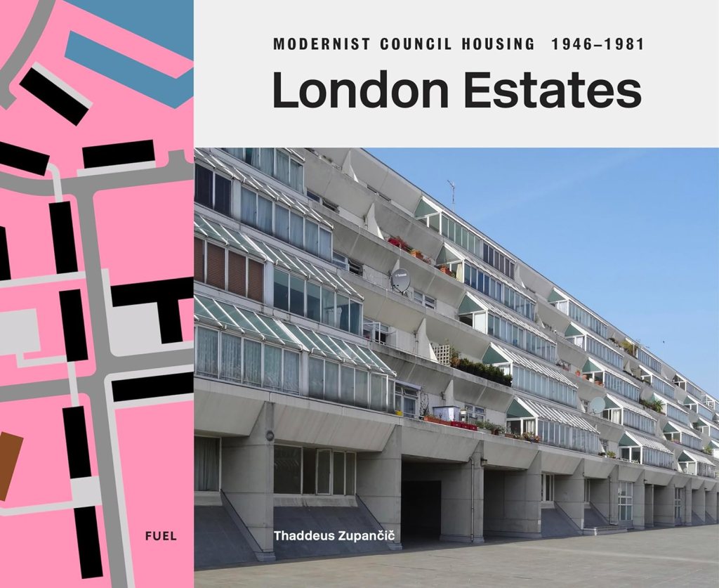 Thaddeus Zupančič, London Estates: M […]
 -
Municipal Dreams wrote a new post on the site reviewer4you.com 1 month, 1 week ago
Kielder Village, Northumberland: Thomas Sharp and a ‘harbinger of a rural revolution’?
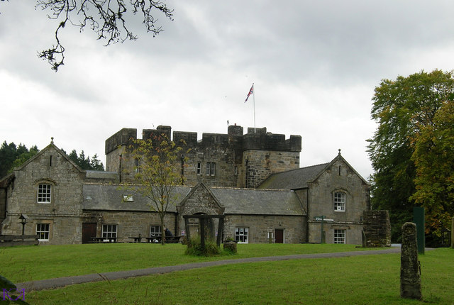 Kielder in Northumberland, […]
No widgets added. You can disable footer widget area in theme options - footer options